

USA RoadAtlas | United States Road Atlas with Offline GPS Navigation app for iPhone and iPad
Developer: Hema Maps Pty Ltd
First release : 09 Apr 2011
App size: 241.76 Mb
Discover the US with USA Road Atlas, the real-time GPS navigation app designed for travelers undertaking everything from interstate RV touring to backroad camping.
USA Road Atlas tracks your exact location on the map as well as allowing you to navigate, plot and save your route. The maps are already preloaded with the app, which means you don’t need any cellular coverage for navigation purposes and to know exactly where you are at all times on your iPad* or iPhone.
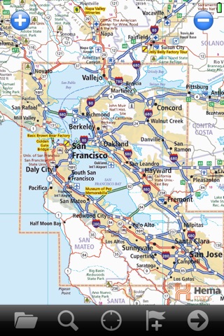
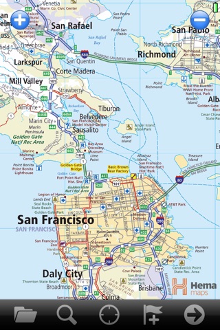
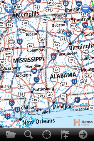
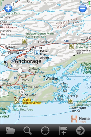
The app features the award-winning seamless mapping from Hema’s Ultimate United States Road Atlas book, containing coast-to-coast mapping at an ideal driving scale of 1:1Million with the busy Northeast Corridor shown at 1:250,000. Major cities are also covered with an overview map of their major roads and suburbs at a detailed scale of 1:250,000.
With a simple user interface, relevant touring symbols and detailed mapping nation-wide, USA Road Atlas is an appropriate offline GPS navigation app to guide those interested in touring or discovering the US’ backroads using their iPhone or iPad.
GPS navigation made easy
Moving map display
Displays and records breadcrumb trail as you move
Simple creation and editing of waypoints and routes
Placename search
Displays Position, Course, Speed, Heading, Altitude and Averages
In-built Wikipedia search function for nearby locations
Name marks as locations of interest (eg Great hiking trail)
Use the Digital Map Shop to purchase more specific maps
Screen orientation lock option (portrait or landscape)
App will continue to track and store data in the background while using other iPad or iPhone features
Note: the app does not do automatic routing or turn-by-turn directions.
Navigation for touring
Driving scale mapping
Points of interest symbols such as campgrounds, hiking, national parks and historic sites on every map
Detailed city maps
Highlighted Route 66
Note: the maps are exactly what you would expect to find in a good national road atlas. City streets and smaller backroads are not shown.
Complete coverage
Continuous 1:1Million coast-to-coast driving scale mapping
USA overview map
Northeast Corridor 1:250,000
City maps 1:250,000
No instructions needed
USA Road Atlas uses simple and user-friendly layout and icons
Intuitive map rollover when scrolling and zooming in and out for seamless navigation
Offline maps
Know where you are offline on your iPhone and iPad with the app
Preloaded offline maps means no 3G or WiFi coverage is needed to view entire maps on your iPhone or iPad
Share your off-road adventure
Email tracks, routes and marks (such as camping spots, hiking trails, or great scenic spots) to your friends and family to share your trip (in open GPX format)
*Although you do not need a SIM Card installed or cellular coverage to utilise the GPS tracking functions on iPad for the app, a 3G-enabled iPad (as opposed to a WiFi only iPad) is necessary to discover and track your location. A WiFi-only iPad does not contain the in-built GPS that a 3G iPad does, however external Bluetooth GPS receivers can be purchased for use with a WiFi-only iPad.
Battery Use Disclaimer: “Continued use of GPS tracking can dramatically decrease battery life.”
Latest reviews of USA RoadAtlas | United States Road Atlas with Offline GPS Navigation app for iPhone and iPad
Very disappointing. Très décevant, je ne recommande pas cette application.
Bought for use in Canada. Canadian maps are extra $. Tried ten day trial version and it showed roads in k country that where deactivated 30+ years ago and did not show new roads. Could not zoom in enough either. Way better maps put there.
This product for price should be more detailed. Its usable, but for deep down detail get Weather Channel app. Its radar map is very detailed and its free!
Ik just bought this app but I didnt like it, the details are not good enough, I wish I could get refunded. There us mo lite version available to evaluate it. This is a scanned map, no details, zooming in doesnt work well.
This app fills a gap in my present map app collection. We often travel out of cell phone range and having an offline road atlas that works well with the GPS is just what I needed. I tested the app in a rural area with spotty cell coverage where Google Maps is slow to load or doesnt load at all. This map showed the main roads in the area and my position on the roads as I travelled along with an arrow indicating my direction of travel. Scrolling is quick and fairly smooth. No, it doesnt have every street. While more detail would be nice, this app is just what it represent to be, a mobile USA road atlas. Road atlases for the entire country generally do not have a lot of detail. It was a nice surprise to find that the app came with a credit to download USGS topo maps (all levels) for one state for free. You can download sections of the topo maps relative to a GPS location to be cached for offline access. You can purchase additional licenses to download topo maps on their website. I like this app better than some other topo map apps I have purchased. I also like the road atlas map and can see myself using it often on my travels this year.